The Royal Borough of Kensington & Chelsea (RBKC) has put out to public consultation its Supplementary Planning Document (SPD), for which will provide a vision, principles, and framework for the delivery of a minimum of 3,500 to a maximum of 5000 new homes on the largest development site within the royal borough.
Background
This known which is referred to as Kensal Canalside is one of the 48 Opportunity Areas within the London Plan. The council is required by the New London Plan to deliver a minimum of 448 new homes per year, with this site being the single largest remaining brownfield development within the borough. This scheme could deliver between 7 and 11 years of the council’s annual’s delivery target is the maximum of 5000 homes were built.
The site and wider context
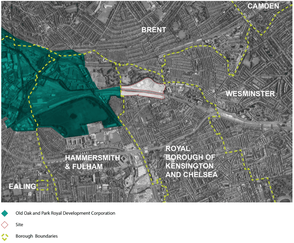
Kensal Canalside lies in the very north of the royal borough. The site sits close to the borders of Westminster, Hammersmith, and Brent. The Old Oak and Park Royal opportunity area, neighbors this site immediately to the southwest. The site is around 15.4 hectares which is home to an eclectic array of commercial and non-profit uses, notwithstanding 16 homes.
The 15.4-acre site is split into two by the Great Western Mainline Railway. The Paddington branch canal and Kensal Green Cemetery which is Grade 1 which forms its northern border. To the east, we have Ladbroke Grove which forms part of the route for the Notting Hill Carnival to the east. The southern perimeter consists of rear private gardens of the residential estates of the Dalgarno ward.
Division of landowners – hindrance or blessing?
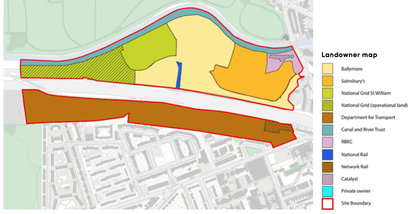
At the time of writing, there are eight different landowners within the opportunity area, with the council working closely with the largest four to ascertain the constraints and construct a united masterplan approach, the four largest site owners being; Ballymore, Network Rail, Sainsbury’s, and National Grid St William. It assumed that the aforementioned land landowners will submit separate planning applications, this will rachet up the need for a cohesive master plan.
Previous land uses
The northern site was operational gasworks in some form or another from 1845 to its decommissioning in 2012. In recent months the two remaining gasometers have been demolished.
The closure of the gasworks in the 1970s gave way for the Sainsbury’s supermarket in 1989 and adjacent Boathouse Centre by NTA Projects Ltd.
It is also the site of the tragic Ladbroke Grove rail crash, where 31 people were killed and 417 injured on the 5th of October 1999. Those caught up in the tragedy are immortalized at a memorial on the south.
Moving to the southern side, the land was home to rail sidings and rail depots, which were used up until 2007, as the main Eurostar depot but was subsequently moved to Temple Mills in Newham, the North Pole Depot then became vacant. Some but not all of this area falls within the Crossrail Safeguarding Directives within an area near Barlby Road being used as a maintenance and storage facility.

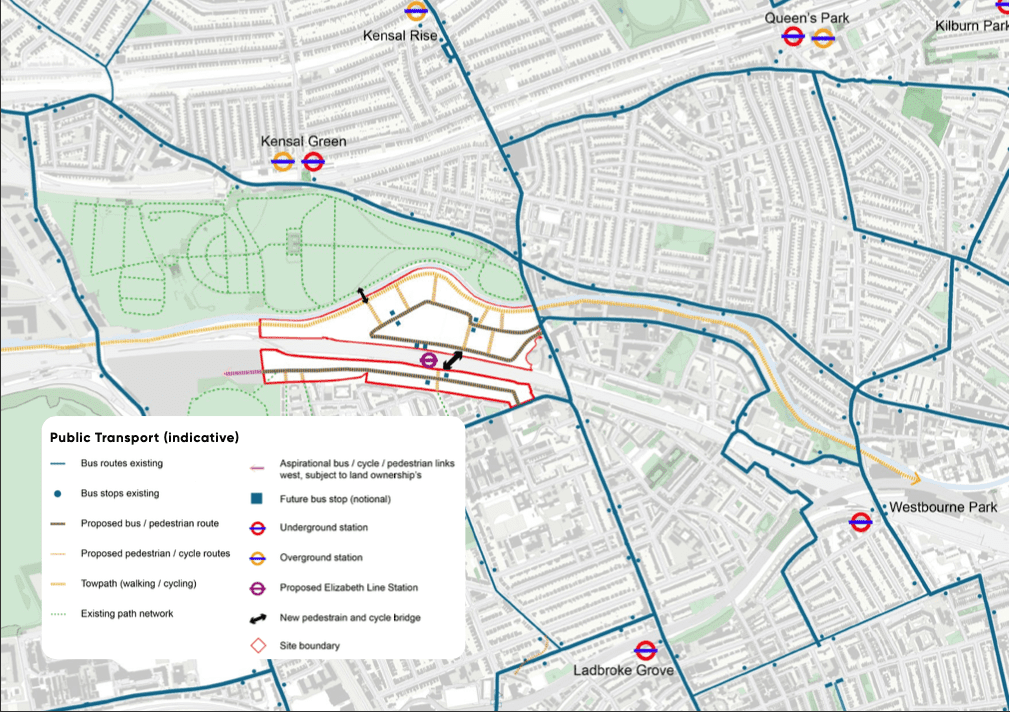
Connections
The two sites are not currently directly linked, as things stand those wishing to go from Barbly Road to the Ladbroke Grove Sainsburys need to use the already congested Ladbroke Grove.
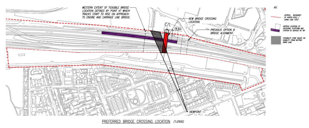
The scheme proposes a pedestrian and cycling bridge, across the GWML with the passive provision for an Elizabeth Line station adjacent to the northern site.
RBKC is keen to have a station in the area, however, developer contributions and central government is key to bringing it to fruition.
There are concerns about the service patterns for such a station and how this would impact journey times as a whole, particularly with an HS2 interchange at Old Oak Common nearby.
A potential comprises may be to only have Heathrow to Abbey Wood services calling here, as not to increase journey times for services from those coming from the Thames Valley.

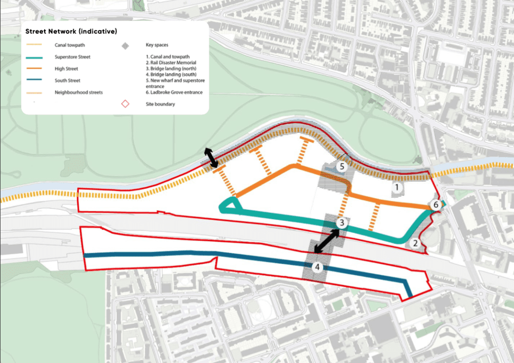
The northern site is envisaged to include a new high street in the east to west in tandem with a replacement Sainsbury’s supermarket and improvements to the canal towpath.
Meanwhile, on the southern side, the improvements are likely to range from improvements to pedestrian access and links through the residential estates within the Dalgarno estate north to south and towards Little Wormwood Scrubs east to west.
Whilst there are mentions of crossings over to Kensal Green Cemetery, questions will need to be answered regarding the placement, operating hours, and potential traffic flows.
Whilst West Brompton Cemetry does operate as a through crossing between West Brompton and Fulham, Kensal Green’s has a more inward and insular layout as a legacy of the fact that Kensal Canalside was once a Gasworks whilst Kensal Green was initially envisaged.
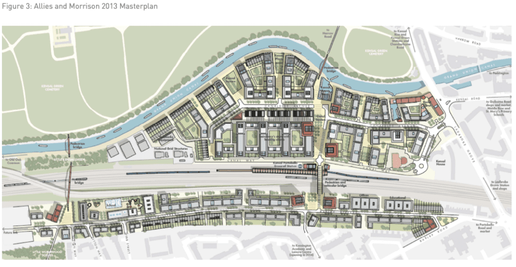
Streets and Spaces
The street network is envisaged to consist of 5 key streets; Canal towpath, Superstore Street which runs more or less in the same alignment of the existing canal reach as well as High Street to the south of the canal towpath and links up with superstore street at the west end of the site and South Street which runs off from Barbly Road and through the middle of the former North Pole Depot Eurostar sidings.
This is linked together by six keyspaces and five side streets from the High Street for residential lead use. The north and south sites are due to be linked by a pedestrian cycle crossing, which will be a genuine alternative to Ladbroke Grove.
Currently, seven different bus routes directly serve the Sainsbury’s supermarket, is implied that bus routes will be routed through the ring road incidentally formed by Superstore and High Street’s respectively.
Live, Work and Visit
Housing
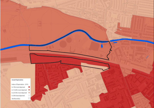
As mentioned previously, this opportunity area provides the largest remaining chance to provide affordable housing within the borough, with the council aspiring to ensure tenure blind housing.
The current policy targets 35% affordable for new residential developments, set by the Mayor of London’s London Plan. However on public sector land, the target is 50% affordable, this could prove to be challenging to achieve because of the high decontamination of the former Kensington Gasworks and the substantial amount of new infrastructure required.
With this under consideration, 30% new affordable housing within the development scenario of 5,000 new homes without additional funding with Passivhaus standard is encouraged.
As the site is half public land and industrial land then it is subject to a 35% affordable housing threshold, the council envisages the 35% affordable housing split of 70-30 between Social rent and Intermediate.
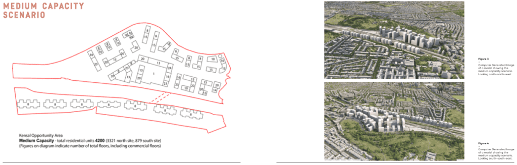
According to initial viability work undertaken as part of a Development Infrastructure Funding (DIF) study commissioned by the Council, indicates a funding gap at 35% affordable when delivering the minimum number of homes (3500), however, it is likely to become viable at 4200 homes with a surplus at 5000.
Of the affordable housing mix, 70% of the affordable housing is to be delivered within 1-2 bed units with 30% being 3-4 bed units, meanwhile, there is an equal 50-50 split between Affordable Homes and Market Homes.
As preference in regards to the allocation for affordable housing is typically given to women and children first and to prevent overcrowding that is common in social housing, this allocation in favor of smaller units may need to be reconsidered.
Whilst between 3,500 at a minimum to 5,000 at its maximum is planned for the site, the Boathouse at the northeast corner at the site owned by the council on a long lease to Catalyst Housing Association provides 16 affordable homes.
If that site is brought forward as part of the wider redevelopment of the site, those residents must be rehoused in accommodation that meets their needs and those wishing to stay within Kensal Canalside must be able to do so.

The DIF study uses the GLA’s calculator to establish education needs in this area over the study period to 2035. Whilst there is a capacity for additional children within surrounding schools when accounting for planned extensions. If 5000 homes were built on this site, a 2-form entry primary school will be required subject to future work.
Within the local immediate area, 51% of the 3,051 jobs are within the creative sector with 60% of businesses recorded as creative activities.
Consequently, the SPD calls for a minimum of 10,000 sums of new office/workspace that reflects and supports the existing creative and cultural industries adjacent to the opportunity area, with the aspiration the wider development provides 2,000 new jobs from start to end of the regeneration scheme.
Character and Massing
Character
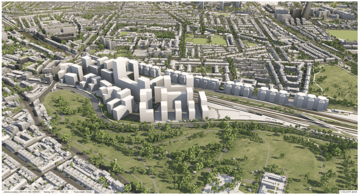
As you would assume a borough with a strong legacy of terraced housing that is broken up by gardens and pocket green spaces, this world-class historic legacy is hoped to be continued within this scheme. A challenge for this scheme, particularly the northern site is the “island” size of the opportunity area, there is the chance to bring forward a scheme with its own distinct cohesive character.
Massing
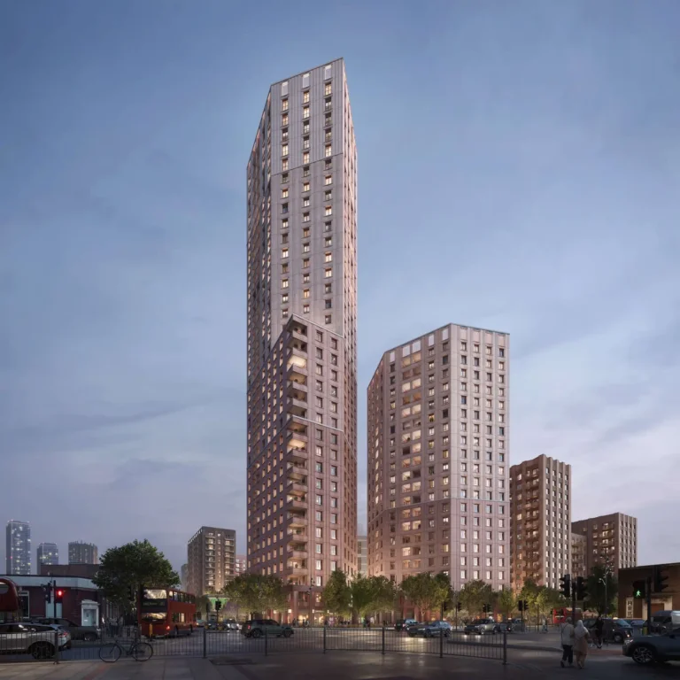
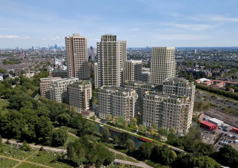
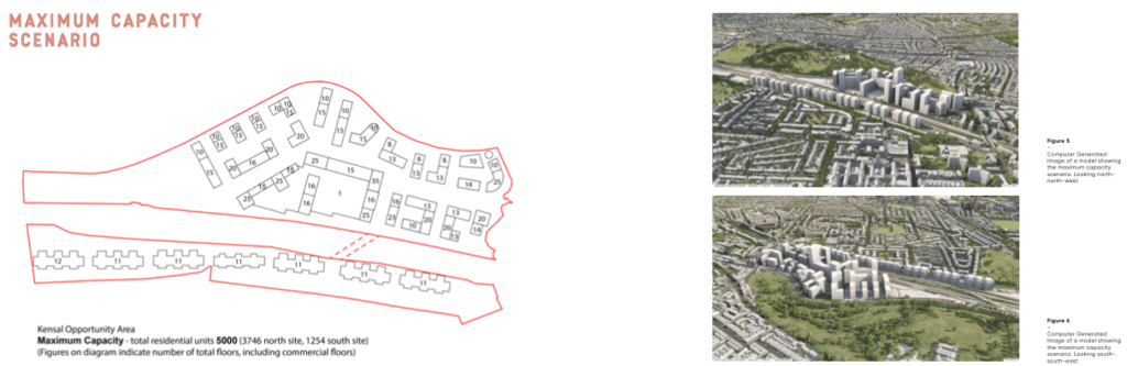
In regards to height, the Grade 11* Listed Trellick Tower, should be used as a maximum reference point for the area. Furthermore, clusters of tall buildings will not be supported. However as pictured below, clustering of tall buildings are essential to enable the maximum 5,000 homes allowed on this site which in turn would enable the biggest benefit to the public in terms of affordable housing and the potentially game-changing Elizabeth Line station.
Next steps
The public consultation on the SPD is open to feedback until midnight on the 24th of May, where comments will be reviewed and necessary amendments made. RBKC will consider the SPD when deciding future planning applications in the opportunity area. Whilst construction is unlikely to start any time in 2021/22, it is likely that works could start within the next three years.