Homes 4 Life’s cross-borough proposal for the former Crowlands Heath Golf Club would deliver one of east London’s largest affordable housing projects, but its location in the Metropolitan Green Belt places the case firmly in the planning balance.
A major affordable housing proposal on the boundary of Havering and Barking and Dagenham is set to test how local planning authorities weigh acute housing need against the protection of designated Green Belt land.
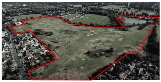
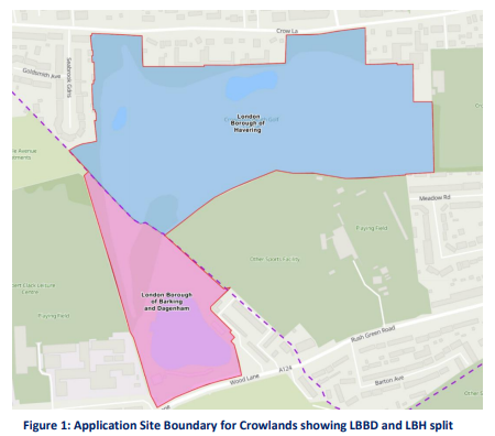
The full planning application, promoted by Homes 4 Life for land at Crowlands Heath Golf Club, off Wood Lane and Crow Lane, proposes 1,298 affordable homes across a 22.5-hectare site straddling the two boroughs. Of these, 998 homes would fall in Havering and 300 in Barking and Dagenham.
The scheme team includes Assael Architecture as architect and masterplanner, Be First Planning Consultancy as planning adviser, and Kanda Consulting on community engagement. The applicant for the construction environmental management documentation is LB Crowlands Heath Limited.
Application strategy and development mix
At the centre of the application is the delivery of 926 flats and 372 houses, all described in the submitted environmental material as affordable.
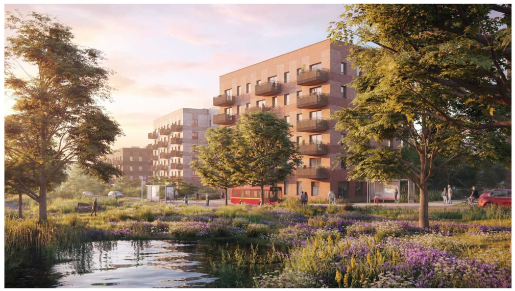
The proposed tenure mix includes social rented and key worker housing, with building heights ranging from two- and three-storey houses to apartment blocks of up to six storeys.
The residential offer is supported by a 405 sq m community unit, about 695 sq m of retail floorspace, a residential management suite, a multi-use games area, padel courts and proposed improvements to Wantz Boating Lake.
The application also includes 486 car parking spaces, four car-club bays and 1,810 cycle spaces.
Planning policy context
The application will be assessed against the statutory development plan, including the London Plan 2021, Havering’s adopted Local Plan 2016–2031 and Barking and Dagenham’s Local Plan 2020–2037, alongside the National Planning Policy Framework and associated Green Belt guidance.
At national level, the central test is Green Belt policy. The site is within the Metropolitan Green Belt, so the councils will need to consider whether the proposal is inappropriate development, whether any grey belt or other national policy provisions are engaged, and whether the claimed benefits amount to very special circumstances capable of clearly outweighing Green Belt harm and any other harm.
The national policy context has become more complex following recent changes to Green Belt policy, including guidance on grey belt land, sustainable locations, the effect of development on Green Belt openness and the so-called golden rules for major housing schemes on land released from, or permitted within, the Green Belt.
The London Plan is also central because it forms part of the statutory development plan for all London boroughs and sets the Mayor’s Good Growth framework. Relevant London Plan themes include making the best use of land, delivering housing and affordable housing, design quality, inclusive access, social infrastructure, sports and recreation, play space, sustainable transport, air quality, noise, urban greening, biodiversity, flood risk and sustainable drainage.
The scheme’s planning case therefore has to do more than demonstrate housing numbers. It must also show how the proposed density, layout, building heights, public realm, play provision, active-travel links, drainage strategy, whole-life carbon approach and ecological mitigation respond to London-wide policy expectations.
At borough level, Havering’s Local Plan, adopted in November 2021, provides the local policy framework for the larger part of the site. It supports housing and affordable housing delivery, infrastructure, design quality and climate change mitigation, while also emphasising protection of the borough’s Green Belt, valued open spaces, biodiversity, waterways and heritage assets.
Barking and Dagenham’s Local Plan 2037, adopted in September 2024, will guide the assessment of the western portion of the site. Its growth strategy places weight on new homes, jobs, infrastructure, sustainable transport, social value and environmental quality, while requiring development to protect parks, historic buildings and the features local people value.
Because the red line crosses two local planning authority areas, the policy judgement will need to be made consistently across both boroughs. That means weighing the same strategic benefits, including 1,298 affordable homes, public open space and transport improvements, against locally specific impacts on Green Belt openness, landscape character, ecology, residential amenity, construction disruption and infrastructure capacity.
Key planning policies in play
The policy framework for the Crowlands Heath application is unusually layered because the site sits in the Metropolitan Green Belt, spans two boroughs and is being promoted as an affordable-led scheme with major landscape and infrastructure commitments.
- National Planning Policy Framework: The central national policy issue is whether development on Green Belt land can be justified. Decision-makers will need to assess Green Belt harm, openness, any grey belt arguments, housing need, sustainable location factors and whether very special circumstances exist.
- Green Belt golden rules: Where major residential development is permitted on Green Belt land, policy expectations around affordable housing, infrastructure, public green space and environmental improvement are likely to be important to the planning balance.
- London Plan 2021: The scheme must align with the capital’s Good Growth objectives, including housing delivery, affordable housing, efficient land use, design quality, inclusive access, sustainable transport, urban greening, biodiversity, air quality, noise, flood risk and climate resilience.
- Havering Local Plan 2016–2031: For the larger part of the site, the council will consider housing delivery against policies protecting Green Belt, open space, biodiversity, landscape character, transport capacity, amenity and infrastructure.
- Barking and Dagenham Local Plan 2037: For the western part of the site, policy considerations include growth and housing delivery, social infrastructure, sustainable transport, environmental quality, open space protection and design-led placemaking.
- Environmental and construction controls: The Environmental Statement, Construction Environmental Management Plan and subsequent planning conditions are likely to be central to demonstrating that impacts on neighbours, ecology, traffic, air quality, noise, contamination and waste can be appropriately mitigated.
Golf course history and acquisition
Crowlands Heath has operated as a nine-hole, semi-private golf course and driving range at Wood Lane, Dagenham, close to Romford. Golf listings describe the course as a links-style layout designed by former Jack Nicklaus designer Mike Pinner and built to USGA championship specification, with players able to play nine holes or repeat the course for an 18-hole round.
Its driving range became a distinctive part of the offer, with golfers hitting into or across the lake towards floating targets. The course has also been marketed as an accessible facility for Essex and east London golfers, with public play, memberships, PGA coaching, a clubhouse bar and function space.
The ownership position is important to the planning story. Although around three quarters of the course lies within Havering, local press reports state that the freehold was owned by Barking and Dagenham Council and leased to Crowlands Heath Golf Club. Homes4Life’s interest became public through a letter to nearby residents in October 2025, which said the company had agreed to purchase the golf course and argued that the club had struggled financially.
Barking and Dagenham Council agreed proposals relating to the disposal of the site in October 2025, subject to planning permission, and reconfirmed the sale agreement at a cabinet meeting in March 2026. Council leader Dominic Twomey said the disposal could benefit thousands of people through new affordable housing, while acknowledging objections from some golf course users and residents.
The acquisition narrative has therefore become part of the wider planning balance: supporters frame the site as an under-used, financially challenged leisure asset capable of delivering affordable homes, public open space and new community facilities, while opponents point to the loss of an established open-air sports use on designated Green Belt land.
Green Belt release framed around public access and housing need
The planning case is likely to focus heavily on the site’s Metropolitan Green Belt status and its location within the Thames Chase Community Forest. Although the land is currently in recreation use as a private golf course, the applicant’s case places weight on the opportunity to convert private open land into publicly accessible landscape infrastructure alongside affordable housing delivery.
The landscape strategy proposes 46,114 sq m of public open space, 13,383 sq m of play space, 769 new trees and seven waterbodies, including five new ponds. Three green corridors would structure the neighbourhood and provide ecological, amenity and movement benefits through the masterplan.
Environmental Statement supports a mitigation-led approach
The submitted Environmental Statement assesses the likely effects of the scheme across traffic and transport, air quality, noise, ecology, climate change, land contamination, waste, socioeconomics, townscape and visual matters. Its overall position is that most impacts can be addressed through embedded mitigation and planning conditions.
The assessment identifies significant benefits from affordable housing delivery, construction employment and new play space. It also acknowledges localised visual effects for some nearby residents and public footpath users, together with ecological impacts requiring further mitigation.
Neighbouring residents, Robert Clack Upper School, West Ham United’s training ground, Romford and Gidea Park Rugby Football Club and future occupants are identified as sensitive receptors during construction.
Proposed controls include acoustic hoarding or blankets where needed, dust and noise monitoring at the site boundary, covered waste vehicles, low-emission construction traffic, hazardous-materials controls and temporary pauses to work if monitoring suggests limits could be exceeded.
With mitigation in place, the assessment reports no significant residual effects for traffic and transport, air quality, noise and vibration, waste, climate change or ground conditions. Measures proposed include dust and noise controls, water management, habitat management, reptile mitigation, ground gas protection and clean soil capping over contaminated land.
Delivery programme and construction management
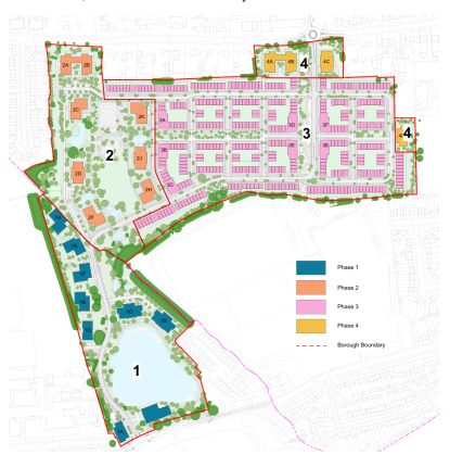
The construction programme is expected to last around 295 weeks, with overlapping phases covering enabling works, infrastructure, construction, fit-out and landscaping.
The phasing strategy starts in the south-west corner of the site and moves north-east. Phase 1 would provide eight apartment blocks of four to six storeys plus community and retail floorspace. Phase 2 would introduce eight six-storey apartment blocks, Phase 3 would deliver 505 two- and three-storey houses and flats, and Phase 4 would complete the remaining apartment blocks.
Transport, logistics and access routes
The plans include new and altered highway junctions at Crow Lane and Wood Lane, as well as a bus-only route through the site linking the north and south. Four bus stops are proposed, alongside improved walking and cycling routes. A barrier would stop general traffic using the development as a cut-through.
During construction, traffic would mainly access the site via the A12, Whalebone Lane, Wood Lane and Crow Lane. The first main entrance would be on Wood Lane, managed by traffic marshals, with a second Crow Lane access introduced later as the first homes are handed over.
The draft construction plan proposes a 48-hour delivery booking system, just-in-time deliveries, wheel-washing, road sweeping, boundary hoarding and segregated pedestrian and vehicle routes. At peak, the project could involve around 50 delivery lorries and 10 skip movements a week.
Decision issues for planners
The application will now be considered by Havering and Barking and Dagenham councils. If approved, planning conditions and legal agreements are expected to secure construction management, transport measures, ecological mitigation, contamination controls, lighting, ventilation, noise limits and local employment commitments.
The decision is likely to turn on the planning balance: whether the delivery of 1,298 affordable homes, public open space, community facilities, active-travel links and environmental improvements can outweigh the harm associated with redeveloping designated Green Belt open space and the local visual and ecological effects identified in the Environmental Statement.
For planning professionals, the application is a case study in the increasingly familiar tension between metropolitan housing need, Green Belt policy, biodiversity and landscape mitigation, active travel, and the deliverability of large affordable-led schemes. The outcome will be watched for how the two authorities assess cross-boundary benefits and harms, and how far construction and environmental controls can reduce the impact of a long build period on surrounding communities.